Home
About Holborn Liveable Neighbourhood
Holborn Liveable Neighbourhood
We want to transform Holborn into a place for people with attractive, healthy, accessible and safe streets for everyone!
We want the air you’re breathing to be cleaner, for there to be more plants and trees, in beautiful new and improved spaces.
We want to make getting around by sustainable and healthy types of transport easier and faster.
Together we want to see Holborn and its communities, businesses and visitors thrive.
To do this we're creating ideas for transforming the area through changes like widening pavements, making some areas car free, improving cycle routes, adding public spaces and plants and trees.
We want to include your suggestions as we shape this project. You can get involved and find out more in lots of ways:
- Share how you feel about Holborn now
- Explore our STARter projects. These are projects we want to start as soon as possible - some are already happening!
- Discover the big ideas we have for changes that could be part of the Holborn Liveable Neighbourhood. These are listed and shown on the map below.
- See the project timeline
- Talk to us at one of our engagement events
- Discover and comment on our plans for evaluating the project plus our strategic aims and objectives.
We're exploring lots of ways we can make improvements across Holborn. Listed below are our initial ideas for these transformational changes but remember - if you want to tell us about a problem or an idea that you have for a specific location, you can also use our interactive map to drop a pin and tell us what you’d like improved or share your general ideas for Holborn in our quick survey.
We've listed below all the projects we're considering so far - you can also see them on our map at the bottom. The map also includes our STARter projects which are projects we are looking to deliver first.
You can see the visualisations of how the areas could look in the gallery below.
If you are interested in cycling you can see how Holborn fits into the wider Camden cycling network in our Cycling Action Plan.
Many of you have already been shaping the project. We've been listening to Holborn's communities who've been sharing their ideas for improvements in our previous calls for suggestions.
During the pandemic we collected ideas on a map and we also have an ongoing map for issues across Camden. Suggestions from both these maps, related consultations and previous engagement in the area including work on the Holborn Vision, have all fed in to our initial plans. Thank you for sharing your thoughts with us so far.
The Holborn Liveable Neighbourhood project is a multi-million pound scheme that will require funding from a range of sources.
We're developing a long-term funding plan for the project, which includes funding from Camden Council, Transport for London, the GLA, central government, new developments (section106/CIL contributions), landowners, and other private sector funding
The project team currently includes LDA Design (working on designs for future possible spaces), Norman Rourke Pryme (providing project management support, highways design and traffic modelling support) and Urban Symbiotics supporting the early engagement phase.
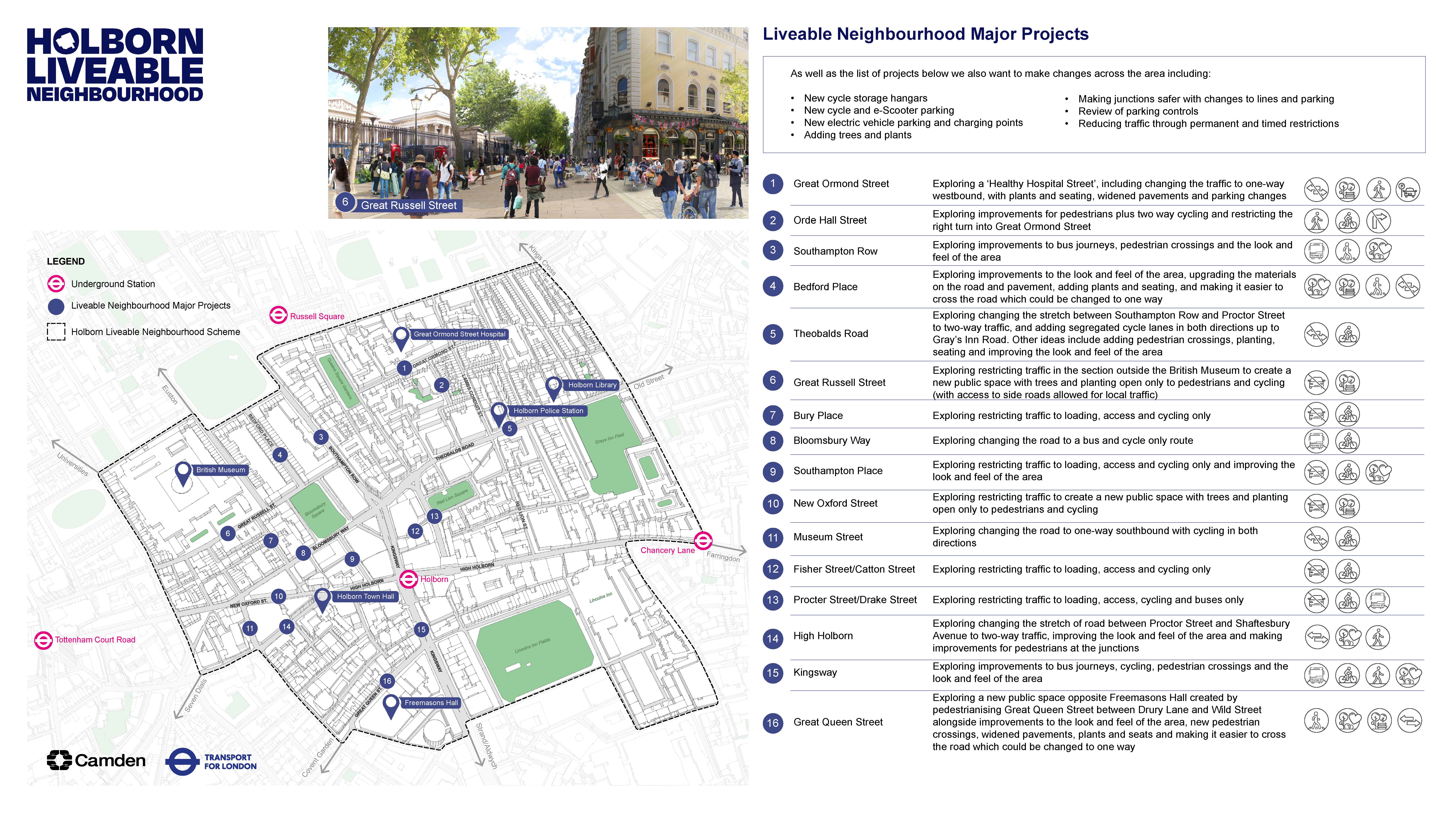
Project locations
- Bedford Place: Exploring improvements to the look and feel of the area, upgrading the materials on the road and pavement, adding plants and seating and making it easier to cross the road which could be changed to one way.
- Bloomsbury Way: Exploring changing the road to two way traffic, improvements to bus journeys and improving cycling
- Bury Place: Exploring restricting traffic with loading, access and cycling only
- Fisher Street and Catton Street: Exploring restricting traffic with loading, access and cycling only
- Great Russell Street: Exploring restricting traffic in the section outside the British Museum to create a new public space with trees and planting open only to pedestrians and people cycling with access to side roads kept
- Great Ormond Street: Exploring a 'Healthy Hospital Street', including changing the traffic to one-way westbound, with plants and seating, widened pavements and parking changes
- Great Queen Street: Exploring a new public space opposite Freemasons Hall created by pedestrianising Great Queen Street between Drury Lane and Wild Street alongside improvements to the look and feel of the area, new pedestrian crossings, widened pavements, plants and seats and making it easier to cross the road which could be changed to one way.
- High Holborn: Exploring changing the stretch between Proctor Street and Shaftesbury Avenue to two way traffic, improving the look and feel of the rea and making improvements for pedestrians at the junctions
- Kingsway: Exploring improvements to bus journeys, cycling, pedestrian crossings and the look and feel of the area
- Museum Street: Exploring changing the road to one way southbound with cycling in both directions
- New Oxford Street: Exploring restricting traffic to create a new public space with trees and planting open only to pedestrians and people cycling
- Orde Hall Street: exploring improvements for pedestrians plus two way cycling and restricting the right turn into Great Ormond Street
- Proctor Street and Drake Street: Exploring restricting traffic with loading, access and cycling and bus access only
- Southampton Place: Exploring restricting traffic to loading, access and cycling only and improving the look and feel of the area
- Southampton Row: Exploring improvements to bus journeys, pedestrian crossings and the look and feel of the area
- Theobalds Road: Exploring changing the stretch between Southampton Row and Procter Street to two way traffic, adding cycle lanes separated from traffic on both sides of the road
Visualisations
High Holborn, Queen Square Gardens
New Turnstile, Theobalds Road
Red Lion Square
Great Russell Street
New Oxford Street
Great Ormond Street
Bedford Place
Great Queen Street
Southampton Place